Cop26 road closures: Congestion maps show how Glasgow travel will be ‘significantly impacted’
and live on Freeview channel 276
What’s the issue: The stark depiction followed police warning protesters not to block the motorways to make things worse during the event from October 31 to November 12.
Home insulation campaigners Insulate Britain, who halted traffic on the M25 twice this week, have told our sister title The Scotsman they also plan to “head north of the Border”.
Advertisement
Hide AdAdvertisement
Hide AdGetReadyGlasgow, which is coordinating travel information, warned: “Based on experience from previous COPs, there is a risk that unofficial fringe activity could occur which could cause further disruption to Glasgow’s transport network”.

How big will COP26 be: A total of 25,000 people are expected to attend the United Nations conference at the Scottish Event Campus (SEC), west of Glasgow city centre, with up to 12,000 there at one time.
GetReadyGlasgow said its scale was “unprecedented in the UK”.
What impact will it have on the roads: The M8, M80, M74 and M77 motorways through and beyond the city are predicted to be “significantly busier than usual”.
Advertisement
Hide AdAdvertisement
Hide AdTailbacks are expected to be lengthened by the closure of the A814 Clydeside Expressway, a major route into the city centre along the north side of the river past the SEC, for security reasons.
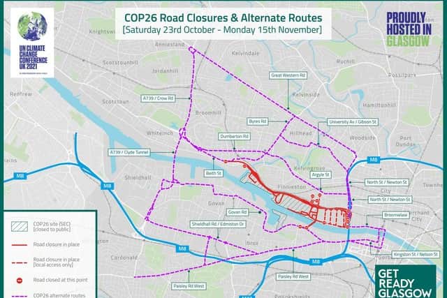
The route will be shut from 9pm on Saturday, October 23 – a week before the conference starts – until 6am on Monday, November 15.
Congestion “may be more severe than usual” because of long-term work on an M8 viaduct at Woodside, near junction 17 just north of the city centre, means its four lanes in each direction will remain reduced to two.
The Clyde Tunnel, which is often a traffic bottleneck, is also expected to be busier than usual.
Advertisement
Hide AdAdvertisement
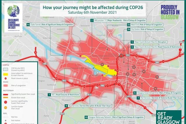
Hide AdCOP26-related disruption is expected to reach its peak on Saturday, November 6 when some 100,000 people are forecast to take part in a mass protest rally in the city centre.
The maps show the congestion risk that day extending from the city centre as far as Anniesland and Maryhill in the west and north, Cardonald, Pollokshields and Govanhill on the south side and Dalmarnock in the east end.
The area around the SEC is expected to be at its busiest on Monday, November 1, when people living and working in the neighbouring Finnieston, Kelvingrove and Yorkhill areas are likely to experience “significant disruption” to travel.
Congress Road, which links the SEC to the adjacent Crowne Plaza hotel, will be closed from Sunday, October 10 to Wednesday, November 17.
Advertisement
Hide AdAdvertisement
Hide AdOther roads in and around the SEC – Congress Way, Finnieston Quay, Tunnel Street and Stobcross Road – will be closed from Sunday, October 24 to Sunday, November 21.
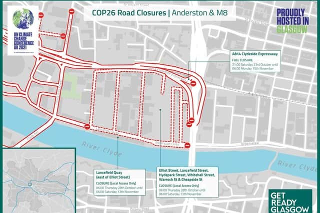
Finnieston Street, which links the expressway and Clyde Arc, will be shut from Thursday, October 28 to Monday, November 15, with local access only from Saturday, October 23.
Other roads between the SEC and the M8 – Elliot Street, Lancefield Street, Hydepark Street, Whitehall Street, Warroch Street and Cheapside Street – will be for local access only from Thursday, October 28 to Saturday, November 13.
The Clyde Arc or “Squinty Bridge” will be restricted to buses, cycles and pedestrians from Sunday, October 24 to Monday November 15.
Advertisement
Hide AdAdvertisement
Hide AdLancefield Quay, to the east, will be closed for the same period.

Castlebank Street, south of the expressway in Partick, will be shut from October 24 to November 21, with restrictions from Sunday, October 17.
What does Transport Scotland say: A transport plan for COP26 published by Transport Scotland stated: “Due to the scale and complexity of the event, which includes one of the largest gatherings of world leaders and alongside planned protest by climate ac